With a $5 million, four-year National Science Foundation grant, a multi-institution marine sciences team with strong Carolina connections is studying the dynamic and complex area off the coast of Cape Hatteras, where multiple water masses converge.
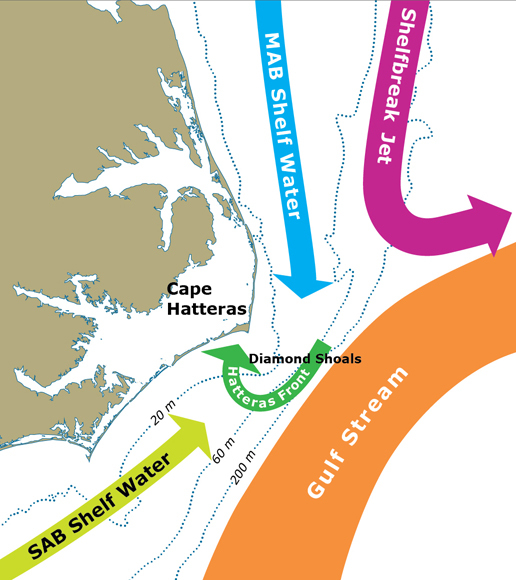
The area off the coast of Cape Hatteras where multiple cold and warm water masses converge has been described as charismatic and complicated. The cool coastal waters from the northeast and the warm waters from the southeast converge here to form the “Hatteras Front.” Scientists say it’s important to understand how the resulting complex circulation responds to strong Gulf Stream and wind variability.
Processes driving Exchange at Cape Hatteras, which goes by the acronym PEACH, is a $5 million National Science Foundation observational and modeling study to understand the mechanisms that drive the exchange of water between the deep ocean and the narrow continental shelf in this area of the Outer Banks. Understanding more about this convergence has implications for the fisheries industry, storm activity, global warming and pollution control.
At the continental shelf, water depth can fall from 200 feet to several miles deep, mixing ocean water with warm shallow water. When cold, nutrient-rich water from the ocean is pushed onto the shelf, it increases the productivity of marine algae and the food web that it supports. It’s a vibrant area for offshore fishing.
“It’s one of only a handful of places in the world where this kind of convergence happens,” said Harvey Seim, a marine scientist in the College of Arts & Sciences at the University of North Carolina at Chapel Hill. “This boundary where the waters come together is also a biological hotspot for the different types of creatures that live in the ocean. There are around 30 different kinds of whales off of our coast, for instance, and they all pass through here.”
Half of the principal investigators involved in the project have Carolina ties. Seim is joined by UNC-Chapel Hill marine sciences professor John Bane, who has been researching this area for 40 years. The lead principal investigator is Dana Savidge (Ph.D. ’97), a marine scientist at the University of Georgia’s Skidaway Institute of Oceanography, who had Bane as her dissertation adviser. She’s joined by Skidaway colleague Catherine Edwards (physics ’99, marine sciences ’08.) Seim was Edwards’ dissertation adviser. The Coastal Studies Institute in Wanchese, led by East Carolina University in partnership with UNC-Chapel Hill and N.C. State, also plays a role. CSI researcher Mike Muglia is currently getting his Ph.D. in marine sciences at UNC-Chapel Hill, with Seim as his adviser. Muglia helps the team reach out to North Carolina fishermen to share the research.
Savidge said there are many practical applications for understanding more about this dynamic region.
“How might this area be affected with global warming? What might that mean to fisheries that depend on certain conditions?” she said. “We’re hoping the data we gather will help better inform a variety of interests from fisheries management to pollution control.”
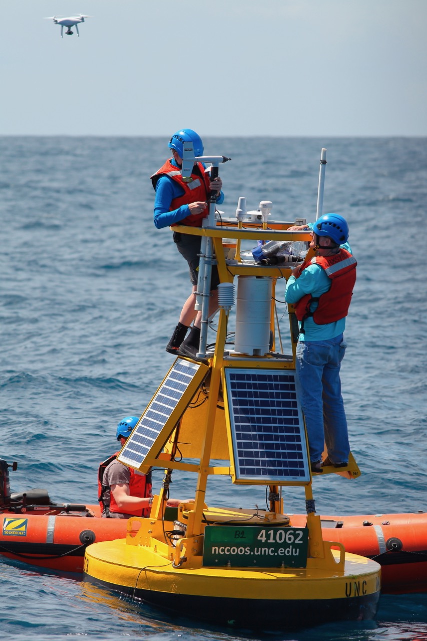
A variety of instruments are being used to collect the data, including two 10- to 12-foot tall buoys that Seim and UNC marine scientist Sara Haines deployed off the coast of Cape Hatteras in April 2017 that will be retrieved on an expedition this Thanksgiving. The buoys measure wind speed and direction, air temperature and humidity, barometric pressure and other vital statistics.
Sensors suspended below the buoys measure water properties like temperature and salinity. Such properties can vary according to atmospheric heating or cooling and freshwater inputs as water moves through different latitudes. There’s a strong contrast between the warm salty shelf water to the south of Cape Hatteras and the cooler fresher water to the north. Properties can thus signify where waters come from, and such contrasts can also affect circulation of the waters at Cape Hatteras.
Savidge installed a network of high-tech, land-based radar stations that scan the waters off the continental shelf and measure the speed and direction of surface currents. This allows researchers to map the area over the dangerous Diamond Shoals, which are otherwise inaccessible.
Edwards is a leading expert in the use of underwater autonomous vehicles called gliders. The torpedo-shaped gliders measure properties such as temperature and salinity continuously as they glide back and forth and zigzags through the water.
“They are super energy-efficient and can be out in the ocean for weeks or months at a time, sending data every four to six hours,” said Edwards, who named one of the gliders Rameses in honor of her Carolina dual degrees. “We’re gathering a fantastic data set and are working with the Navy and with NOAA (the National Oceanic and Atmospheric Administration) to improve ocean and hurricane models.”
Edwards’ use of gliders to monitor Hurricane Florence’s trajectory was featured recently in Wired magazine.
Edwards is also working on outreach components of the grant that include introducing sixth- through 12th-grade girls to the gliders through “Girl’s Engineer It! Day” and hosting public lab nights at Skidaway Institute.

“If you’ve got a big yellow robot, people will talk to you,” Edwards said. “Part of our mission is to make the research available to a broader audience.”
Bane believes the PEACH team will bring new insights into what’s happening off the coast of Cape Hatteras. Savidge and Edwards recently returned to Chapel Hill to give talks about their research in support of the department of marine sciences’ 50th anniversary, which is being celebrated this academic year.
“It’s the best group of co-investigators I’ve worked with in all my years here at UNC-Chapel Hill,” Bane said. “Everyone is bright and interesting, and they all bring unique strengths to the project.”
For Savidge, it’s been rewarding to keep returning to North Carolina’s Outer Banks, “a fabulously wild and remote place.”
“This four-year grant really gives us time to see how all the puzzle pieces fit together,” she said.
N.C. State University and Woods Hole Oceanographic Institution in Massachusetts are co-principal investigators on the PEACH project.
By Kim Weaver Spurr ’88